


Next bus Barcelona
Next bus Barcelona의 설명
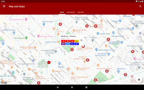
다음 버스 바르셀로나 를 사용하면 바르셀로나 및 주변의 모든 버스 정류장 (야간 버스 ( "Nit Bus") 포함), TMB 버스 및 버스 정류장에서 버스가 정류장에 도달하는 데 걸리는 시간을 확인할 수 있습니다. 다른 운영자의 버스 및 전차).
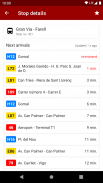
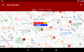
정류장 코드를 입력하기 만하면 (버스 정류소에서 볼 수 있음) 정류장에 도착한 모든 노선과 노선에 남은 시간을 확인할 수 있습니다. 정류장 코드를 모르더라도 걱정하지 말고지도에서 정류장을 선택할 수도 있습니다.
응용 프로그램으로 할 수있는 다른 작업 :
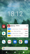
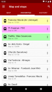
• 가장 가까운 버스 및 전차 정류장을 참조하십시오
• 각 정류장에서 어느 노선이 정차하는지 확인하십시오
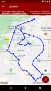
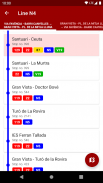
• 각 노선의 노선을보고 다른 노선과의 환승
• 당신이 쉽게 확인할 수 있도록 좋아하는 정류장을 저장
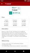
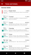
• 대중 교통 티켓 및 요금 확인
• 또는 홈 화면에 위젯을 추가하여 앱을 열 필요조차 없습니다.
이 서비스는 모든 TMB 및 AMB 버스 정류장과 트램 정류장에도 적용됩니다. 따라서 Authosa, Baixbus (Mohn, Oliveras, Rosanbus), SGMT, Soler i Sauret, TCC, TMB, TRAM 및 TUSGSAL과 같은 모든 서비스 운영자가 포함됩니다. 바르셀로나, 바달로나, L' Hospitalet de Llobregat, Castelldefels, Cornellà de Llobregat, El Prat de Llobregat, Esplugues de Llobregat, Gavà, Montcada i Reixac, Montgat, Sant Adrià de Besòs , Sant Boi de Llobregat, Sant Feliu de Llobregat, Sant Joan Despí, Sant Just Desvern, Santa Coloma de Cervelló, Santa Coloma de Gramenet, Tiana 및 Viladecans. AMBtempsbus 및 iBus 시스템과 유사하지만 더 완벽합니다.
이 앱의 제작자는이 회사들과 아무런 관계가 없습니다. 데이터는 이러한 연산자에서 가져 오며 정확하지 않을 수 있습니다.
Next bus Barcelona - 버전 5.8.1
(16-01-2024)Next bus Barcelona - APK 정보
APK 버전: 5.8.1패키지: cat.ereza.properbusbcnNext bus Barcelona의 최신 버전
다른 버전들


동일 카테고리의 앱


